In Deep Dungeon Doom, I follow #Gygax75 and #Dungeon23 to create a D&D dungeon campaign in a few minutes per day for one year. I post irregular updates here. To get the daily rooms, follow me on Mastodon and Twitter.
“Step 2 requires sitting down with a large piece of hex ruled paper and drawing a large scale map. A map with a scale of 1 hex = 1 mile … will allow you to use your imagination to devise some interesting terrain and places, and it will be about right for player operations such as exploring, camping, adventuring, and eventually building their strongholds” (Gary Gygax, Europa, April 1975, 18).
Making the Wilderness Map
Scale
We might assume a “large piece of hex ruled paper” is tabloid (A3) size, although I have no idea where one would acquire hex paper in the mid ’70s, especially tabloid size.1 Even at that size, one mile per hex makes what seems to my eyes a too-small area for building strongholds. I suppose I’m used to establishing a barony and having extensive space to explore.
When perusing Dave Arneson’s First Fantasy Campaign (Judges Guild) map and text, though, I imagine a more intimate setting for several PCs and their interactions, the 1977 map’s scale notwithstanding.
Furthermore, with Deep Dungeon Doom’s focus on the dungeon, a small wilderness area feels right, and Ray Otus points out that we’ll have “time to draw a larger scale map in week 5” (The Gygax 75 Challenge, 11).
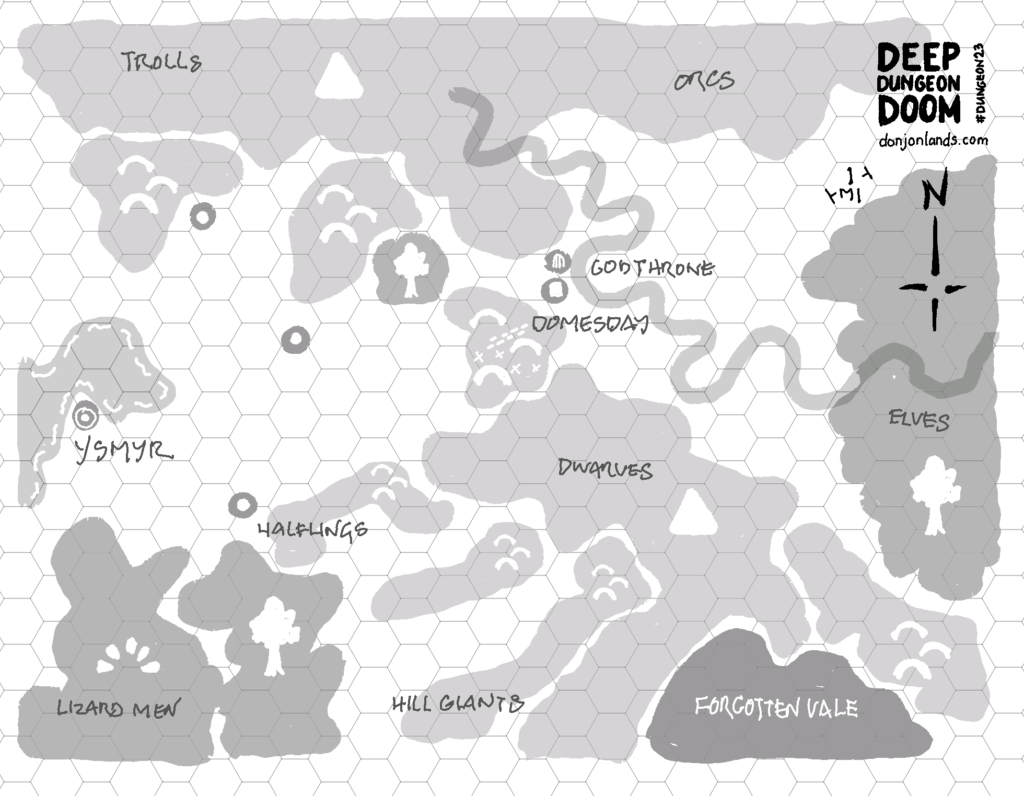
The reMarkable gives me a hex grid that comes out to ½" hexes on a letter-size page.2 One hex per mile—and limiting the map size to 8" × 10", so as to fit on either US letter-size or European A4 paper—gives us an area of 16 × 20 miles or 320 square miles. Intimate.
Settlements
Following Otus, I place a large town on the coast and a couple villages support-distance away. I like to work in as many terrain types as is logical for a map’s aesthetic appeal and to exercise the wilderness encounter tables, which are differentiated by terrain.
Mysterious Locations
I choose a remote, vacant area between highlands for a mysterious location. I don’t know why the vale is forgotten or why it might be important to the campaign, but I’m guessing it’s got something to do with the Doommaker herself.
Also, inspired by the real-world map source, the central hills connecting the north and south mountain ranges also mark a geographical divide between the eastern highlands and the western lowlands. A long, straight, sloping tunnel runs between the two. Parallel to it, a series of level tunnels joined by sheer precipices runs the same length. Both structures are huge and blocked by rubble, debris, and monsters. A surface-level track also traverses the hills.
Cyclopean Tunnels
The parallel tunnels are a remnant of the Greater Ones. The sloping tunnel was used for ground transport. The other, after the builders diverted the river, was a series of locks for watercraft. The elves of the eastern woods re-diverted the river some longtime ago.
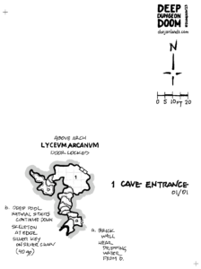
Dungeon and Base Town
The dungeon, which I name after its most prominent feature, is located off-center, and I place the base town—a stronghold—nearby. I also add regions inhabited by PC races, plus monstrous races for tension.
So early in the campaign—the PC party is still practically at the dungeon entrance, I don’t expect the neophyte adventurers to explore the wilderness soon. I highlight only geographical features on the map, marking each with a single large icon, and restrain myself from adding further detail—apart from an encounter table.
Wilderness Encounter Table
I divide the wilderness map into quadrants, marked by the central hills. Entries separated by a pipe “|” should be read west|east; those by a slash “/” north/south. For example, a 3 result yields halflings when traveling in the west or elves while exploring east of the central hills.
| 2d6 | Result |
|---|---|
| 2 | Magic-User (Men*) (L or N) |
| 3 | Halflings|Elves |
| 4 | Knights** |
| 5 | Orcs/Dwarves |
| 6 | Men*|Humanoid* |
| 7 | Roll on Wilderness Encounter Table* |
| 8 | Bandits |
| 9 | Lizard Men|Goblins |
| 10 | Ogres |
| 11 | Trolls/Hill Giants |
| 12 | Magic-User (Men*) (C) |
| * See Wilderness Encounter Table (X57-8). ** Knights? I don’t know yet. |
Daily #Dungeon23 Rooms on Mastodon and Twitter
I post the dungeon map, updated with the day’s room and a brief description, every day on Mastodon and Twitter.
1 Avalon Hill of course. In “Hexmaps and Random Encounters Before D&D,” Tom Van Winkle notes that the makers of Outdoor Survival (1972) sold 22" x 28" hex maps for amateur game designers (Tom Van Winkle’s Return to Gaming, September 2, 2023). In an email exchange, Tom points me to a notice in the July 1964 issue (Vol. 1, No. 2) of the Avalon Hill General. Under the heading “Design Your Own Games” on page 1, AH offers the large hex maps in sheets for $1.00 each.
2 Only interesting for reMarkable users: To achieve half-inch hexes, I use the reMarkable template medium hex grid, portrait orientation, exported to PNG, and printed at 176 ppi. Use the highlighter in different colors and export grayscale to get the varying shades. I have to turn the tablet landscape, because reMarkable got the hex orientation wrong. The engineers maybe never played Outdoor Survival, whose map board has the horizontal lines at top and bottom. This is, therefore, the “correct” orientation.
Added footnote 1. [19:04 8 September 2023 GMT]
Edited footnote 1 to include the source. [5:45 11 September 2023 GMT]